

El Ávila: The Protective Lungs of Caracas
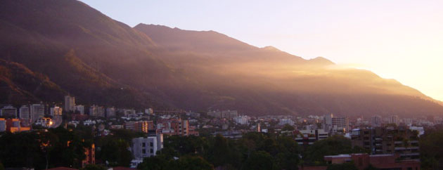
31 October, 2011Santiago de Leon de Caracas – better known simply as Caracas – is the capital and largest city of Venezuela. Caracas is located in the northern part of the country, following the contours of the narrow Caracas Valley on the Venezuela coastal mountain range, the Cordillera de la Costa. Lying close to the Caribbean Sea, the Caracas valley is separated from the coast by the so-called “green guardian” – a steep mountain range rising north of Caracas, named Cerro El Ávila. Culminating at Pico Naiguatá, 2,765 meters above sea level (9,071 ft), the city’s many skyscrapers and multi-storey buildings sit dwarfed at the foot of this mountain, which nestles among the clouds. And it is here in these mountains that an unexpected refuge from the hustle and bustle of the city can be found.
The El Ávila National Park was formed in 1958, fulfilling an interest in the protection of the forested mountains surrounding Caracas prevalent since the 19th century. Named after the Cerro El Ávila mountain range, the park also goes by the name of Waraira Repano, originating from an indigenous name for the area. El Ávila has long been recognized as an important resource and the native inhabitants that lived in the mountains approximately 500 years ago built trails connecting the city to the coast. These trails were used in the 17th century by Spanish colonizers, along with pirates and merchants travelling to the city, the oldest trail being aptly named the Camino de los Espanolẽs. These, and more recently created trails and roads, are now walked daily by thousands of visitors, the majority of which are Venezuelans. The park’s extensive biodiversity has also attracted a great deal of scientific interest.
El Ávila consists of over 81,800 ha, encompassing a wide variety of ecosystems that vary along the altitudinal gradient. In the lower areas of the mountains, the vegetation mostly consists of drought-adapted species, such as cacti and shrubs, but above 600m semi-deciduous forests and then sub-mountainous evergreen forests can be found. Between 1,500m and 2,200m above sea level, cloud forest dominates, but above this height, lack of water permits only sub-páramo vegetation. In these highest zones, some of the park’s 180 orchid species can be found flowering. Among these is Venezuela’s national flower, Cattleya Mossiae (pictured below). More than 1,800 plant species in total can be found within the park, several of which are endemic to the Cordillera de la Costa, such as the giant tree known as “el niño” (Gyranthera caribensis). At least 17 plant species are endemic to El Ávila itself, and the park is home to several species of lichen and fungi notable for their beauty and rarity.

The park is also home to a great diversity of animals, with more than 100 butterfly, approximately 120 mammal, 20 amphibian and 30 reptile species. The red howler monkey (Alouatta seniculus), brown-throated sloth (Bradypus variegatus), nine-banded armadillo (Dasypus novencinctus), Brazilian porcupine (Coendou prehensilis), lesser anteater (Tamandua tetradactyla), crab-eating fox (Cerdocyon thous), paca (Agouti paca) and tapir (Tapirus terrestris) are among the mammals found within the park. But outnumbering these are the park’s 500 bird species, which represent thirty-six per cent of Venezuelan avifauna. Nine of these bird species are endemic to Venezuela: the violet-chested hummingbird (Sternoclyta cyanopectus), black-throated spinetail (Synallaxis castanea), guttulated foliage-gleaner (Syndactyla guttulata), scallop-breasted antpitta (Grallaricula loricata), Caracas tapaculo (Scytalopus caracae), handsome fruiteater (Pipreola formosa), white-bearded flycatcher (Phelpsia inornata), Venezuelan bristle-tyrant (Pogonotriccus venezuelanus) and rufous-cheeked tanager (Tangara rufigenis). The endangered helmeted curassow (Pauxi pauxi) is also found within the park.

El Ávila is managed by the National Institute of Parks (INPARQUES), and has been divided into different management zones, where the activities permitted vary. For example, the Integral Protection Zone includes the sub-páramo and cloud forest and here access is only granted to INPARQUES personnel and scientists. In the Primitive and Wilderness Zone, access is also restricted, with activities devoted to scientific research, monitoring and educational activities. Low-impact recreation is allowed within the Recreation Zone, where infrastructure building is permitted. But the majority of large man-made structures can be found within the Special Use Zone, many of which were built before the establishment of the park, and as such are not necessarily compatible with its conservation interests. Examples include the old Caracas-La Guaira road, telecommunication structures and hydroelectric plants. Perhaps of most interest to El Ávila’s visitors, however, is the hotel named after the German naturalist and explorer, Alexander von Humbolt, and the cable car that leads to it.

From the intersection of Caraca’s Avenida Principal de Mariperez and Avenida Boyaca, this cable car climbs 2,153m before descending behind the mountain towards the coast to the city of Macuto, where it opened in 1956, along with the Humbolt hotel. The construction of the cable car and hotel began during the dictatorship of Marcos Pérez Jiménez and under the work of the architect Tomás Sanabria, and has become one of the symbols of modern Venezuela. After the collapse of Pérez Jiménez’s rule in 1958, the hotel and cable car became neglected, falling into disuse for 20 years. Finally reopened in 2002, facilities found at the cable car’s summit include several themed restaurants and lounges, and even an ice rink. Now carrying such a large number of people into the park, concern has been raised that if not properly regulated, the cable car could become a threat to the park’s conservation. During weekends approximately 4,000 people take the cable car up to El Ávila, while approximately 200 vehicles use the road that is headed for Galipán.
Galipán is one of three native villages found within the park, along with Hoyo de la Cumbre and El Corozo, which existed before the park’s creation and are not thought to threaten its preservation. However, to the west of Caracas, in the lower areas of the park, many slums can be found, which also predate the parks creation but have grown uncontrollably since. All of these settlements are found within El Ávila’s Environmental Protection and Recuperation Zone. At the time of the park’s formation, 70,000 people already lived in these areas. By 1980, this number had reached 234,161, and in 1990, 600,000 people were estimated to be living in this zone. Today’s number is likely to be even higher. Inclusion of these areas within the park’s boundaries may do little to benefit it, although it is argued that this perhaps makes their management easier.

Homeless people and criminals are also claimed to occupy these lower areas of the park, and the ignition of bonfires in grassy areas has led to forest fires on several occasions. Fire represents one of El Ávila’s greatest threats; in the summer of 1960, for example, an 11-day blaze burned 1,400 ha of the southern slope. The establishment of African grass species on the southern slopes of the mountain, such as Panicum maximum and Melinis minutiflora, has facilitated the spread of fires. The “savanization” of El Ávila is in fact the most serious consequence of introduced species, having altered the mountain’s ecological dynamics and led to annual fires and the reduction of forest area. The majority of exotic plant species introduced into the park were once grown commercially during the 17th and 18th centuries. Only three agricultural communities now exist within the park, Culebrillas, Santa Rosa and Sanchorquiz, but in areas where the park limits are not well marked, there has been concern that surrounding agricultural areas are encroaching. Speculation has been made, for example, that the farming town of Birongo, found some 5km away in Miranda State, may now occupy park land.
Towns near Birongo, among others, have also been implicated in the poaching which commonly occurs in the eastern sectors of the south side of the park. Although only subsistence hunting, no information exists as to what is being hunted, due to the lack of personnel in this area. El Ávila has the largest number of employees and the greatest infrastructure development of any Venezuelan park, but resources are concentrated close to Caracas in an area that only represents an eighth of the total park area. As a result, problems have ensued not only in the eastern sector but also on the more isolated northern slope. This area was, for example, severely affected in 1999, when torrential rains – and the flash floods and debris flows that followed – killed 30,000 people and destroyed more than 60,000 homes. Since then many of the areas on the northern slope no longer exist as recreation areas. The Ministry of Science and Technology is researching urban design solutions to avoid further tragedies.
The majority of conservation programs within the park are, however, directed towards solutions for forest fires. Since 1946, a 20m wide by 24.5km long firebreak has prevented fires from spreading to higher elevations on the south side. With the help of companies such as Chinotto and Panamco, and the Metropolitan University, INPARQUES conducts maintenance programs for this important firebreak. In 2001, a command center was built to control forest fires across Venezuela. An external monitoring system was also installed and is run by the National Guard, who also has at its service a special helicopter for fighting forest fires. The Pajaritos firefighting camp, found in the Special Use Zone, is the largest and best in the country. With the help of individuals who use the park, 40 million bolívares (US $ 40,000) were collected to be used for reforestation after the 2001 fires, when an area greater than the total area burned during the two previous years combined blazed.
With the creation of El Ávila National Park came the protection of its forested mountains and the biodiversity that they support, which serve not only as a recreational area but also as a buffer against urban expansion. The extensive vegetation found at El Ávila has led it to be called “the lungs of Caracas”. And from the mountain’s top, an incredible view of the city that it guards can be gained. The proximity of El Ávila to Caracas means that thousands of its inhabitants can take advantage of this great asset, but this ease of access has also made El Ávila vulnerable to a number of threats. A great deal of resources are provided to the park, but more even-spreading of these over its entire area is needed. Support must also continue to come from those people visiting and residing within the park, who may need to become guardians themselves, if the protection of this great giant lung is to be successful.
Follow Sounds and Colours: Facebook / Twitter / Instagram / Mixcloud / Soundcloud / Bandcamp
Subscribe to the Sounds and Colours Newsletter for regular updates, news and competitions bringing the best of Latin American culture direct to your Inbox.